1) Badwater (lowest point in Western Hemisphere)
First thing in the morning we drove to Badwater where there is a small amount of water that looks very gross (see picture), a sign saying you are 282 ft below sea level, and behind you is a mountain with a sign on the side stating where sea level is. The water isn't actually "bad", but its really, really salty. One funny thing about this place is all over the place where there is land people have dug small holes...so they are a little lower.

Mountain next to Badwater that on the side has a sign showing where sea level is.

3) Awesome dry fall
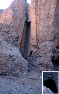
About 50 yards further into the canyon where the natural bridge was there was a cool looking dry fall. It was over 40 ft tall (not in the picture that Troy is standing at the bottom...in the bottom corner is a zoomed in view of Troy). We thought about trying to climb it but the ground in front of it was all loose rocks and would have been too dangerous.
 Dry fall in the canyon with the natural bridge...Troy is standing at the bottom of the fall (zoomed in view in the corner for clarity).
 4) Devil's Golf Course
Just a mile or so down the road was the Devil's Golf Course . The sign in front of it says "Crystallized salts compose the jagged formations of this forbidding landscape. Deposited by ancient salt lakes and shaped by winds and rain, the crystals are forever changing. Listen carefully. On a warm day you may hear a metallic cracking sound as the salt pinnacles expand and contract."
5) Artist Palette
Artist Palette is not far from the Devi's Golf Course and is a few mile loop that takes you through a range of mountains that are all different colors. Pictured below is from the main view, but in reality all along the road are very colorful mountains. The one I told Troy reminded me of a huge mound of ice cream of various flavors.

6) Explored unmarked canyons
Troy and I hiked for quite awhile to check out two canyons that from the road looked pretty cool, but once we made it up to them we found out that it was impossible to get further than about 10 ft into them.
7) Found cool unmarked canyon
Third try was the charm. We were able to hike for miles into this canyon (we actually climbed to a peak and couldn't see where the canyon stopped). Quite a ways into it we found several abandoned mines that were really cool. Below is a picture taken from the entrance to one of the mines...we didn't explore them because that would be stupid.

Then right next to the mines was a pretty steep side of a mountain that we could see had a trail cut across the face of it. Troy and I decided to climb up there just to see how crazy the path actually was. Turns out its really crazy...I had to stop half way across it because over half the "trail" didn't exist. It was just loose small stones, but as long as you walk standing straight up you won't slide...if you lean you fall. Troy is fearless and practically ran all the way to the top and around to the front of the mountain...I waited to see if it was worth it...it wasn't.
Crazy path cutting across the face of this mountain...I made it half way Troy went all the way.
8) Zabriskie Point
We went to Zabriskie Point that overlooks part of ther region we were hiking as well as Golden Canyon. We were going to hike Golden Canyon but were too tired after several hours of hiking in the morning.
9) Rest
After so many adventures in the day and half in the desert we decided to spend the afternoon relaxing and doing some reading at Furnace Creek. This was definitely needed since even when we tried not to have an adventure one would find us everywhere we went.


2 comments:
Superman Ice Cream!
Btw, the picture of mountains with the mark of sea level is cool too.
it's funny that people dug holes to be lower than than the lowest point below sea level. also, Artists Palette is really, really pretty.
Post a Comment